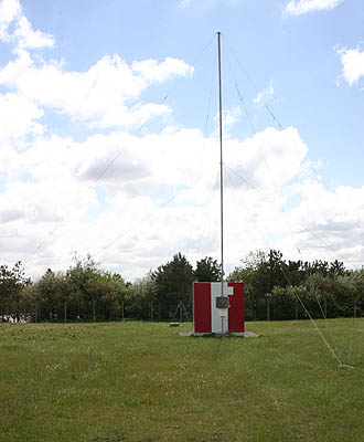
Le Touquet / Paris Plage Locator LT, May 2006 Le Touquet / Paris Plage Locator LT, May 2006
 It has taken a long time until we had a route description for this beacon.
You wil ask: “Why, you where there to take a photo?”
Oh, it is easy to say where the beacon is.
It is locates at the dunes, south of the river La Canche,
there where the river is running into the Channel. That’s simple, or…
We were guided by someone working on the airport.
He found that the most easy way to get us at that spot.
But with some help by Google Earth is here the way to the beacon.
Coming from Calais:
Take the A16 diriction Boulogne/Rouen/Marquise, this is partly a toll road (follow the A16 over 57 km).
Take exit 26 direction Le Touquet/Etaples/Montreuil/Stella-Plage/Merlimont.
At the end of the exit, at the roundabout,
take the first turn onto the N39/Route d'Hilbert direction Le Touquet/Etaples/Merlimont/Stella-Plage.
Go left to follow the N39/Route d'Hilbert. Follow the N39.
Take at the roundabout exit 5 = road over the bridge.
Just after passing the bridge you can see at the RHS the runway of Le Touquet airport.
Follow the N39 (Avenue de Général.De Gaulle) for 5 km, going straight on at two roundabouts.
Go right at Boulevard Dalloz (direction north).
At the roundabout take the 5th exit, Avenue de Quentovic (direction west).
Go straight on at the roundabout.
Go right at Boulevard Thierry Sabine (direction north).
Follow this road and it will come at the river La Canche.
The road turns to left, following the river to the Channel,
and after some time to the left again. After this last turn the beacon is at the LHS.